Ruta Waghmare-Baptista
- View some of the earliest maps of Mumbai made from the year 1626 onward, from the permanent collection of the Dr. Bhau Daji Lad Museum
- Learn the basic elements of map making
- Explore how ‘Bombay’* evolved into the megacity ‘Mumbai’. The unique challenges and opportunities that the city has faced.
- Engage with the old maps of Mumbai through fun activities!
- Suitable age group: 6 and above
*The name ‘Bombay’ is used in a historical context here. The name of the city officially changed to Mumbai in 1996.
Human curiosity about distant lands and people has led to numerous inventions to explore and better understand the world around us. Cartography or map-making has been one of the ways people have tried to break down unfamiliar terrain. The earliest charts of the skies or celestial maps were produced in ancient Egypt and Mesopotamia about 1530 B.C.E. (Before Common Era). In Sippar, Iraq, archaeologists excavated a stone slab depicting what is believed to be the earliest known surviving map to be found – dated between 700 to 500 B.C.E – presently on display at the British Museum.
In 1903, Cecil Burns, the Principal of the Sir Jamsetji Jeejeebhoy School of Art, Bombay, was appointed as Curator of the Dr. Bhau Daji Lad Museum (formerly the Victoria and Albert Museum, Bombay). He wanted to make the Museum popular amongst the people of Mumbai and therefore created facsimiles of different maps of Bombay which were published in the ‘Gazetteers of Bombay City and Island’ in 1909. He began building a visual archive of the city through maps, photographs, and 3D models. The maps on display at the Dr. Bhau Daji Lad Museum showcase the long, incredible history of how seven seemingly insignificant islands evolved from a cluster of fishing villages into a financial powerhouse and India’s most cosmopolitan metropolis at the turn of the 19th-20th centuries.
Visitor Engagement and Experience Programme
The maps in the Museum are a useful tool to discuss and develop activities and workshops to understand the history of Mumbai as well as the contemporary urban planning issues faced by the city’s policymakers and residents. Adjacent to the display of the maps is a gallery named Origins of Mumbai and this space can double up as a visitor engagement centre for engaging with maps. All the following activities can be offered as ticketed workshops or free weekend events.
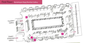
Map of the Kamalnayan Bajaj Mumbai Gallery, on the first floor of the Dr. Bhau Daji Lad Museum. The numbers marked 7, 8, 9 are the areas where the maps are displayed.
Activities for children and families:
1. The Museum’s education programme offers worksheets and interpretive guides aimed towards 7 – 12 year olds that enable self-led study of the maps in the collection. This can be taken a step ahead to design additional thematic worksheets that will be available at the reception or as part of special activities with schools or on family weekends. All worksheets are available in English and Marathi.
2. A family activity involving layering present-day maps of the city and older ones to make ‘corrections’ in the boundaries, names, places depicted on the older maps.
3. Various precincts in Mumbai have interesting names, the origins of which are not always clear to even our locally based visitors. An interactive game on the website or a printed sheet in the information box will be a fun activity for visitors of all ages.
4. The team can also create an activity sheet of the Byculla area and conduct a virtual or in-person activity to explore the history of Byculla through the old names and buildings marked on the map.
5. Tools related to cartography can also be displayed in a small case in the Origins of Gallery Room.
6. Audio guides describing stories about select maps and imagined stories.
Activities for 15+ and adults:
1. Mapping the sacred geography and the many myths of the city, which was originally inhabited by the Kolis or the fishing communities. The local, cult goddesses of Mumbai are still prevalent in different shrines and names in the city.
2. Mapping migrations – Mumbai is a city built by migrants. Maps and dioramas depicting the development and density of housing draw attention to the very current and relevant use of space and areas on the lines of communities and class. This is an important issue as various localities in the city are increasingly seeing gated residential areas with homogenous communities living in isolation, replacing the multi-faceted identity of these very localities.
3. A participatory activity to understand common prejudices and multiple voices of the visitor demographic by asking them to anonymously (or non-anonymously) identify areas they feel are safest or dangerous according to their own perspectives. These experiences can be collected on-site or digitally to build a larger narrative of how we uniquely navigate and perceive the city.
Special events that are free and open to the public:
1. Talks and lectures on cartography and Mumbai’s history told through different perspectives. This can include a session with the Google Maps team on how cities are mapped and what statistical data can tell us about map visualisations.
2. A book club dedicated to reading and discussing books on Mumbai’s history and contemporary urban issues told from the perspective of Western as well as Indian authors. This can be sub-divided into a young teen’s book club and one meant for older audiences.
3. Talks by architects and urban planners on the future of Mumbai. This can be a collaborative, themed, walking tour, or even a lecture/presentation format.
4. There are few unique maps in the library and special, ticketed, by-registration only events for small groups to come see the prints under the supervision of a conservator and historian or Museum curator who can discuss the maps with the visitors. This can be one of the perks offered in the already existing ‘Friends of the Museum’ membership programme for ‘Gold’ (i.e. higher cost, higher benefits) category.
Visual and Tactile Accessibility
1. A map of the seven islands of Mumbai before they were joined with all the contours of the hills to be made and placed along with the display to understand the “shape” of the city. This can be mounted on a panel in the Origins of Mumbai Gallery.
2. Display labels in Braille for those that are visually challenged. This can be done in the Origins of Mumbai Gallery, adjacent to the main display of the Maps since visitor movement is restrictive in the passage where the maps are displayed due to space limitations.
3. All the cases with map displays are at a height of 3 ft or slightly higher and angled to face upward and out of easy visual reach of anyone visiting the Museum with wheelchair assistance. This can be improved by incorporating images of the maps in a visual slideshow of Old Bombay Photographs that is shown on a loop in the Origins of Mumbai Gallery. A brochure and a QR code linking to detailed visuals and information about the maps can be placed in an information box that the Museum already has, which is of an appropriate height for visitors in a wheelchair.
All the activities below can be offered in-person and through virtual sessions or by scanning QR codes placed around the each individual map listed below.
How to read a map?
Maps are a visual archival tool, guiding the viewer through detailed, thematic imagery that helps the viewer navigate an area. The main types of maps:
- Historical maps.
- Physical maps or Toposheets that emphasise natural land features such as hills, lakes, rivers, coastal areas, forests, and contours in the landscape.
- Political maps that show cities, provinces, country boundaries, etc.
- Thematic maps such as those that show ecology, population demographics, etc.
Satellite imagery has made our everyday maps incredibly sophisticated, however, there are certain basic elements that help us read maps whether they are on paper or digital:
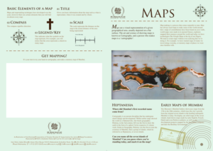
- Title – states basic information about the map indicating what it represents, the year it was created, and by whom it was created.
- Compass – orientation or direction with an arrow pointed towards the North.
- Legend – symbols indicating a specific place, for example, a cross is a common representation for churches in political maps.
- Scale – the ratio of the actual distance between two places compared to the distance represented on the map.
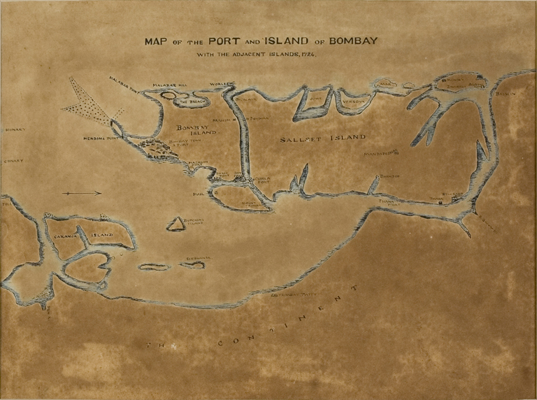
Early Maps of Bombay
Ptolemy, a Greek geographer, was one of the first cartographers to produce a world map as a sphere instead of a flat map that indicated his belief that the Earth is, in fact, spherical and not flat. It is in his expansive, eight-volume work titled ‘Guide to Geography’ (c. 2nd century C.E.) that we find the first mention of Mumbai as ‘Heptanesia’ or a cluster of seven islands.
The map of the seven islands shows an archipelago of scattered islands, separated from each other by swamps and sea inlets. Juxtaposed with the map of Heptanesia is another three-dimensional map showcasing the island of Bombay between 1700-1800. This was after the first land reclamation in the city had begun on the western seafront with the Hornby Vellard road connecting Bombay to Worli. This reclamation filled the breach between the islands of Bombay and Worli, preventing the flow of seawater from coming inland during high tide.
Heptanesia and Bombay Islands, 1700 – 1800; glass, clay, pigments; 1909-1912, made at the erstwhile V&A Museum, Bombay; 192.5 x 93 cm.
Image credit: Dr. Bhau Daji Lad Mumbai City Museum.
Activity #1 / Mumbai as ‘Heptanesia’
Click here to zoom into the map of ‘Heptanesia’. Can you identify all the seven islands?
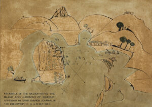
Davies’ Sketch Map of Bombay Harbour, 1626; facsimile, watercolour and ink on paper, 1909-1912, made at the erstwhile V&A Museum, Bombay; 25 x 35.5 cm. Image Credit: Dr. Bhau Daji Lad Mumbai City Museum.
One of the earliest recorded maps of Bombay is this sketch by David Davies, made in 1626. Davies was part of a crew of English and Dutch ships that launched a joint attack on the Town of Bombay over a few days with the aim of sacking the city.
What is Davies trying to convey through the map? Rather than the aerial view that we are accustomed to seeing in maps, we see a 2-dimensional horizontal perspective of the land.
Observe the way the island is depicted with the mainland in the background. The map also emphasises the relationship between the harbour and Bombay. The bay is marked with the sign ‘Ry’.
Activity #2 / Sketch Map of Bombay Harbour
Compare the map above with a Google map of Mumbai and guess from which direction this was drawn and what does it depict?
Imagine you were a traveller and your ship has just docked at Mumbai’s port. What would you see? Can you draw a sketch of how Mumbai would look to tourists visiting the city today!
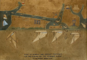
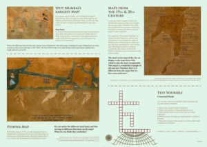
Map of Bombay and the District prepared by the Peshwa’s Agent, 1770; facsimile, watercolour and ink on paper, 1909-1912, made at the erstwhile V&A Museum, Bombay; 25 x 35.5 cm. Image credit: Dr. Bhau Daji Lad Mumbai City Museum.
Observe the map carefully…why are the ships upside down? What do the fish represent? This map is a little mysterious!
This ‘coded’ map could have been possibly been prepared by the Maratha army to plan an attack on the surrounding areas of Bombay.
The Marathas, Siddis, Dutch, French, and British powers were all interested in controlling the islands of Bombay due to its important location on the international sea trade route. The original map, prepared just before a war between the Maratha armies and the British.
The fort of Bombay is marked as ‘Ingraj’ or English at the centre while the other surrounding forts that were under the Maratha Empire are depicted with four sides having circular ‘bastions’ or structures that protrude out of the angles of a fort for defence purposes.
Activity #3 / Decode the symbols!
Can you count how many forts, ships, and fish are represented here? Click here to take a closer look at the map!
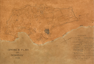
Grose’s Plan of Bombay, 1750; facsimile, watercolour and ink on paper, 1909-1912, prepared at the erstwhile V&A Museum, Bombay; 25 x 35.5 cm. Image credit: Dr. Bhau Daji Lad Museum, Mumbai
The map on the left depicts the ‘Fort’ that was built by the British army around the Bombay Castle to protect their administrative headquarters and military barracks located in this area. Even though the Fort walls were broken down in 1862, the area is still known as the ‘Fort’ precinct.
Activity #4 / Map the bastions!
Click here to view the map in detail and know its history. Can you count how many bastions are noted on the map? What do you see in this area of Mumbai today?
Here are a few photos of old bastions!
Glass negative images: a) Outer and Centre Bazaar Gate; b) Stanhope Bastion and Malborough Gate; c) View of the Rampart overlooking the Tank Bastion; d) New Lunette Mill and East Rampart.
Image credits: Dr. Bhau Daji Lad Mumbai City Museum
Check out the map below to see how a modern-day Google Map image of the Fort Precinct in Mumbai compares to the layout of the Fort of Bombay! This overlay also gives an idea of the reclamations – including the docks and Ballard Pier – that took place post the 1860s.
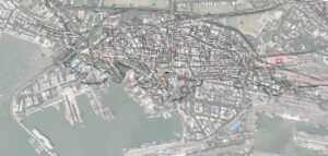
Plan of the Bombay Fort (1771-1864) overlaid on the present-day Google Map of the Fort Precinct, Mumbai.
The port city of Bombay has welcomed people from across the Indian subcontinent as well as far away lands. Trade with the East India Company brought a lot of people from across the world to this city. Bombay began witnessing waves of migrations, that have still not ebbed, as people flocked to the ‘City of Gold’.
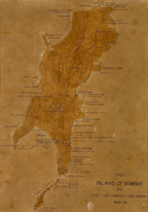
Map of Island of Bombay by Capt. Thomas Dickinson; facsimile, watercolour and ink on paper, 1909-1912, prepared at the erstwhile V&A Museum, Bombay; 25 x 35.5 cm. Image credit: Dr. Bhau Daji Lad Museum, Mumbai
This map of the island of Bombay, based on Capt. Thomas Dickinson’s survey that began in 1812, is one of the earliest ones to depict the city as it looked after the early reclamations. The old place names indicated on the map reveal the socio-cultural origins of these names. This gave rise to place names such Bhandarwarra (after Bhandaris or toddy tappers) or Kamatipura, where the labourers hired for construction activities settled in the late 18th century.
Place names provide an interesting backstory that gives us a clue to the reclamation activities that were carried out there. Oral legends influenced how place names change or retain their original intent. A few place names were also based on the earlier botanical species found there. For example, Parel comes from the name of the local tree paral or padel (species: Heterophragma chelonoides), a deciduous tree native to the Indian subcontinent.
Other place names – Mahim (named after Mahikavati), Mahalakshmi, Ghodupdevi, Mumbadevi – are a clue to the old cult goddesses worshipped by the fishermen, who were the earliest inhabitants of the islands. The Banganga Tank and the Walkeshwar Temple first built c. 12th century C. E. are also some of the most sacred locations in the city.
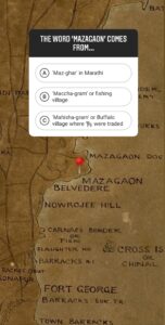
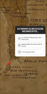
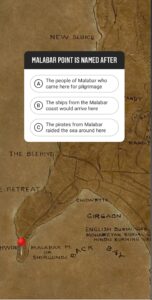
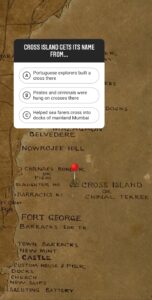
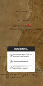
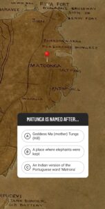
Activity #5 / Trivia Game
Guess how the following well-known places in Mumbai got their names! Answers are given at the end of the Visitor Experience Programme.
The map of the Island of Bombay by Thomas Dickinson also provides a clue to the defence structures that once existed in Mumbai. There were a total of 18 forts in and around Bombay, affecting the geopolitical skirmishes for the islands till the Company Government established the main Fort Town. Some of the other forts around the main islands of Bombay are seen in the earlier map by the Peshwa’s agent.
Glass negative images: a) Mahim Fort; b) Kala Killa or Dharavi Fort; c) Sion Fort
Image credits: Dr. Bhau Daji Lad Mumbai City Museum
Activity #6 / Find the Forts!
Click here to zoom into the map of the Island of Bombay by Thomas Dickinson. How many old forts can you find? Can you name them? Work with your friends or teachers to trace the history behind each of these forts.
Think about all the changes that have taken place in the city, including the place names.
Do any of the places or street names mentioned in the maps above sound familiar? Many of these street names were changed from 1995 onward to displace the names of the British personalities after whom they were named. Names of Indian personalities and public figures replaced the British names, though public memory has still retained some of the older, local versions of the street names that retain a hint of its unique character and history. The name of the city itself changed from Bombay to Mumbai in 1996.
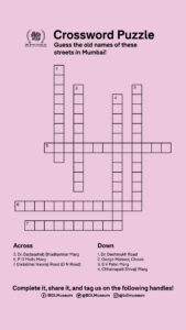
Activity #7 / Solve the Crossword!
The crossword puzzle below lists out the current names of important streets in Mumbai. Can you guess what the corresponding older names were? Take a screenshot or save the image and send us the completed activity!
Activity #8 / Create your own map!
Choose any of the following themes to create your own map!
- What is your favourite thing about Mumbai? The food, its architecture, cinema, or its various iconic locations? If you had to explain this aspect of your city to a friend living far away, how would you best guide them to explore the city? Draw a map and share it with us via social media handles!
- Mumbai is rapidly expanding and developing and all of us have been stuck in traffic or floods caused in the city at some point over the last few years. Conceive an idea of Mumbai where these problems are minimised and represent it on a map.
- Take a walk around the Museum and observe the labels. Do you see objects from across India displayed in the showcases? Point on a map where the regions these articles are from. You can even draw your own map depicting the various arts of India!
Marketing and Publicity
The aim of the marketing activity is to raise awareness that the Museum has a rare collection of maps and invite people to learn about the city’s history.
On-site publicity –
- A simple two-page foldable brochure stating the highlights of the Museum’s collections – including the maps – and how they are displayed across the Museum. These can be given at the entrance ticket counter or printed in large posters and mounted on the standees strategically placed around the Museum.
- Regular training to Gallery Attendants to encourage people to go visit different collections in the Museum
- Advertising the Museum’s collections and maps on a changing digital display in recreational areas such as the Museum Shop and Cafe.
- Commissioning unique products: limited prints of the maps on archival paper which can be collectible items, bookmarks with select details or complete maps printed on them, calendar with a drawing of the map printed on each month’s leaf, coasters that show a complete map of Mumbai when assembled together, postcard sets of printed maps for tourists, puzzles for children with the map of Heptanesia representing 7 islands of Mumbai.
- Using social media to engage people in discussing the histories behind the maps in the collection, sharing behind-the-scenes photos of conservators working on the maps.
- Hosting teacher training sessions with local municipal and private schools to encourage teachers to use the maps from the Museum’s collection that are available on Google Arts and Culture to teach Mumbai History and basic geography lesson plans.
Off-site publicity
- Collaboration with Google India to develop an app where an old map of Mumbai shows up as an option to Google Maps for a special marketing campaign.
- The Museum has a map of Mumbai dated to 1934 when railways came up. A tie-up or collaboration with the railways to display these at important stations near the Museum for generating interest.
- Tie-ups with local restaurants and hotels where tourists stay during visits to Mumbai. The Museum can print brochures and maps pointing out how to get to the Museum and organise private tours for guests of the hotels that agree to display or sell the Museum’s map merchandise.
Acknowledgements
First and foremost, I would like to thank Dr. Madhuvanti Ghosh for her guidance and inputs through the 5-day Vitural Workshop on Museum Collections and Visitor Experience, Dr Vandana Sinha and the entire team at CAS AIIS for seamlessly coordinating the logistics of this workshop. Thanks are also due to Mrs Tasneem Mehta, Director, Dr. Bhau Daji Lad Museum for her constant support and guidance, my colleagues Ruchika Jain and Vijay Nakti who helped source the images from the database, and Dr. Andre Baptista who helped with text and image edits.
Resources:
Burns, C. Catalogue of the Collection of Maps, Prints and Photographs illustrating the history of the Island of Bombay. Bombay: Times Press, 1918.
Edwardes, S.M. The Rise of Bombay: A Retrospect, Bombay: The Times Press, 1902
Rohatgi, P. Godrej, P. and Mehrotra, R. (Eds.), Bombay to Mumbai: Changing Perspectives, Mumbai: Marg Publications, 1997.
Sheppard, S.T. Bombay Place-names and Street-names: An Excursion Into the By-ways of the History of Bombay City. Bombay: The Times Press, 1917.
Correct answers to Trivia game: 1. Mazagaon – A; 2. Old Woman’s Island – B; 3. Malabar – C; 4. Cross Island – A; 5. Breach Candy – C; 6. Matunga – B.